Monday, 18 November 2013

mySELF...


NAME : Siti Munirah Bte Mohamad Said
METRIC NO.: a12a571

DATE OF BIRTH : 21/10/1992

PLACE OF BIRTH : Sandakan, Sabah.
 
FACULTY: Faculty of Entrepreneurship (TOURISM)
 
YEAR : 2 ( semester 3) 
UNIVERSITY MALAYSIA KELANTAN


EVALUATION OF THE ASSIGNMENT: 
 
From this assignment I get to know many amazing and wonderful places around the world that hopefully someday I can go to visit. Actually by doing this assignment, not only I get the information about many fantastic destinations around the world, but I also gain the knowledge from my research on the place that I read. To all amazing people who kindly to read and see my post, i hope the information i have in this blog can help and give you more knowledge about it as well. And if you can, please comment and give suggestion or maybe you all can tell me about other good places that you know.


Sunday, 17 November 2013

GREAT SMOKY MOUNTAINS NATIONAL PARK - USA


The Great Smoky Mountains National Park was established on June 15, 1934 after a long process of land purchases starting in with Congress' authorization in 1926. this place has seasonality, so the traveler who came hare can choose the season they want to visit. each season has it own beauty and attraction either from it's flora or fauna. Not to worry, the park has several visitor centers inside the park as well as some in the surrounding areas. These centers offer various ranger-led programs, facilities, services, and exhibits. Visitors can get information to help plan their visit to the park and get answers to their questions from park rangers.


The Great Smoky Mountains are home to over 100 native species of trees, more than are found in northern Europe. The park was designated an International Biosphere Reserve in 1976 and a UNESCO World Heritage site in 1983. At 480 feet, Fontana Dam, on the southwestern boundary of the park, is the tallest concrete dam east of the Rocky Mountains. The tangle of brush and trees forms a close-packed array of air breathing leaves. The water and hydrocarbons exuded by the leaves produce the filmy “smoke” that gives the mountains their name.


the woodland and craggy peaks bloom more than 1,600 species of flowering plants, some found only here. Shrubs take over in places, creating tree-free zones called heath balds, laurel slicks (because of the shiny leaves), or just plain hells (because they are so hard to get through).


Great Smoky Mountains National Park is open 24 hours a day, 365 days a year. However some secondary roads, campgrounds, and other visitor facilities close in winter. 
there is plenty of park, thinly laced by 384 miles of mountain roads. You can pull off the road, park the car, and stroll one of Great Smoky's many Quiet Walkways, quarter-mile paths into what the signs call a “little bit of the world as it once was.” Eight hundred miles of hiking trails, from a half-mile to 70 miles long, also give you that world. Relatively few visitors walk the trails; most prefer to stay in their cars.
The park, which covers 800 square miles of mountainous terrain, preserves the world's best examples of deciduous forest and a matchless variety of plants and animals. Because it contains so many types of eastern forest vegetation—much of it old growth—the park has been designated an international biosphere reserve.


the hikers often take advantage of the many trails at Great Smoky Mountains National Park, including a path that goes through New found Gap in Tennessee.
                                                                                                       

  Ridge upon ridge of forest straddles the border between North Carolina and Tennessee in Great Smoky Mountains National Park. World renowned for its diversity of plant and animal life, the beauty of its ancient mountains, and the quality of its remnants of Southern Appalachian mountain culture, this is America's most visited national park.     


The Smoky Mountains are among the oldest on Earth. Ice Age glaciers stopped their southward journey just short of these mountains, which became a junction of southern and northern flora. Rhododendron and mountain laurel thrust from the weathered rocks

PAMUKKALE - TURKEY


Pamukkale, which literally means 'cotton castle', is the name the Turks gave to the extraordinary site of Hierapolis. The name was inspired by the preternatural landscape of bizarre forms created by calcite deposits from the hot springs that surface through a fault: mineral forests, petrified cascades and terraced pools of an immense natural nymphaeum. The ancients attributing healing powers to the hot springs (35 °C) equal to their power to metamorphose the landscape, they founded a thermal station on the site in the late 2nd century. This site is exceptional by vurtue of its superlative natural phenomena - warm, heavily mineralized water flowing from springs creating pools and terraces which are visually stunning.


It is also a natural site in Denizli Province in southwestern Turkey. The city contains hot springs and travertines, terraces of carbonate minerals left by the flowing water. It is located in Turkey's Inner Aegean region, in the River Menderes valley, which has a temperate climate for most of the year.


In this area, there are 17 hot water springs in which the temperature ranges from 35 °C (95 °F) to 100 °C (212 °F).
At this place also the traveler can visit the former Roman Bath of the ancient city of Hierapolis has been used as the site of the Hierapolis Archaeology Museum since 1984. In this museum, alongside historical artifacts from Hierapolis, there are also artifacts from Laodiceia, Colossae, Tripolis, Attuda and other towns of the Lycos (Çürüksu) valley. 


In addition to these, the museum has a large section devoted to artifacts found at Beycesultan Hüyük that includes some of the most beautiful examples of Bronze Age craft.


As recently as the mid-20th century, hotels were built over the ruins of Hierapolis, causing considerable damage. An approach road was built from the valley over the terraces, and motor bikes were allowed to go up and down the slopes. When the area was declared a World Heritage Site, the hotels were demolished and the road removed and replaced with artificial pools. Wearing shoes in the water is prohibited to protect the deposits.


VALLEY OF THE MOON OR VALE DE LUA - BRAZIL


The Valley of the Moon or locally known as Vale de Lua in the Brazilian Highlands is part of the Chapada dos Veadeiros National Park, which is located in the Brazilian state of Goias. It is located a few kms from the town of Sao Jorge. Today the park occupies only 1/10th of the actual area and is spread over an area of 65,515 ha (655 sq km).  This ancient plateau is believed to be a whopping 1.8 billion years old.


 Vale Da Lua is a stone basin that has been carved by the San Miguel River. This name translates to moon valley and named it the erosion of rocks by the river has left them smooth and gray in color similar to the month view. Valley has some of the oldest rock formations in the world, with about 1.8 billion years old. The river has created grottoes, caves, waterfalls and bizarre rock formations, to form a labyrinth in the narrow canyon walls. 


  National Park Vale Da Lua declared a UNESCO World Heritage site in 2001. Vale Da Lua is well known throughout the world for flora and fauna and breathtaking scenery. Visitors were surprised by the smooth gray rocks, which are believed to have been washed over the centuries by the magical waters of the majestic San Miguel River.


Climate The average annual temperature is between 24-26 degrees Celsius. It ranges from a minimum of 4-8 degrees Celsius and highs of 40-42 degrees Celsius. With a height of between 600 and 1650 meters, the area ranks as the highest plateau in Central Brazil.

Viewed from space, the brightest region on earth. Quartz and smooth stone causes light. Surrounding forest is abundant with wildlife and lays claim to many types of orchids. The river has made the area a work in progress, constantly eroding and changing the landscape.

  
The highlight of the park and the state is the Serra da Santana Goias, at 1691 meters above sea level. Vale Da Lua area has the greatest biodiversity and rich fauna consisting of various endangered species such as the maned wolf, anteater, pampas deer, and many others.


GREAT BARRIER REEF ISLANDS - AUSTRALIA


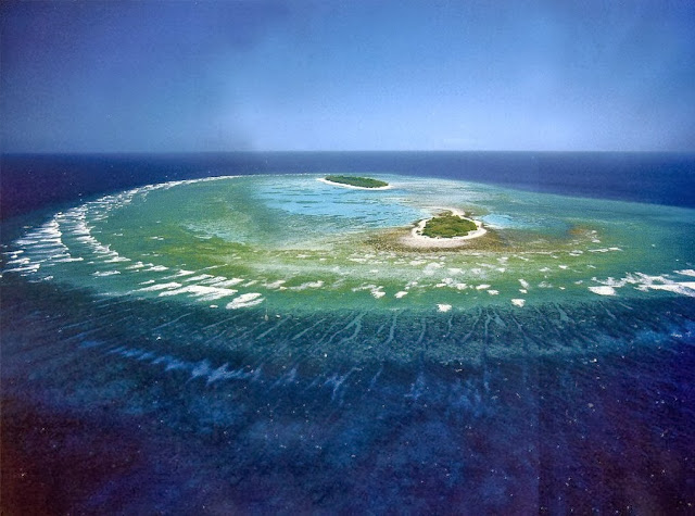
GREAT BARRIER REEF ISLANDS One of Australia's most remarkable natural gifts, the Great Barrier Reef is blessed with the breathtaking beauty of the world's largest coral reef. The reef contains an abundance of marine life and comprises of over 3000 individual reef systems and coral cays and literally hundreds of picturesque tropical islands with some of the worlds most beautiful sun-soaked, golden beaches.

Great Barrier Reef's islands are simply enchanting, one visit is just enough to keep you coming back for more. You have the choice of over 100 islands, from unique and exotic islands to the Whitsundays and the remarkable Northern Islands. The Great Barrier Reef will redefine your idea of paradise.


The islands in Great Barrier Reef such as Bedarra Island, Brampton Island, Daydream Island, Dunk Island, Green Island and many more are sure will make anybody who visit there will experience good memory and satisfy themselves with the beauty of that Islands.


The Great Barrier Reef is the world's largest coral reef system composed of over 2,900 individual reefs and 900 islands stretching for over 2,600 kilometers (1,600 mi) over an area of approximately 344,400 square kilometers (133,000 sq mi). The reef is located in the Coral Sea, off the coast of Queensland, Australia.


The Great Barrier Reef is one of the seven wonders of the natural world, and pulling away from it, and viewing it from a greater distance, you can understand why. It is larger than the Great Wall of China and the only living thing on earth visible from space.


CNN labeled it one of the SEVEN NATURAL WONDERS OF THE WORLD. The Queensland National Trust named it a state icon of Queensland.
The Great Barrier Reef can be seen from outer space and is the world's biggest single structure made by living organisms. This reef structure is composed of and built by billions of tiny organisms, known as coral polyps. It supports a wide diversity of life and was selected as a World Heritage Site in 1981.

The Great Barrier Reef supports a diversity of life, including many vulnerable or endangered species, some of which may be endemic to the reef system.

NIAGARA WATERFALLS


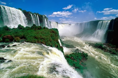
Niagara Falls is the name of three waterfalls that located between Canada and US or more specifically, between Province if Ontario and the States of New York.  From largest to smallest, the three waterfalls are the Horseshoe Falls, the American Falls and the Bridal Veil Falls. The Horseshoe Falls lie on the Canadian side and the American Falls on the American side, separated by Goat Island. The smaller Bridal Veil Falls are also located on the American side, separated from the other waterfalls by Luna Island. 


 Niagara Falls were formed when glaciers receded at the end of the Wisconsin glaciation- the last ice age, and water from the newly formed Great Lakes carved a path through the Niagara Escarpment end route to the Atlantic Ocean. While not exceptionally high, the Niagara Falls are very wide. More than six million cubic feet (168,000 m3) of water falls over the crest line every minute in high flow, and almost four million cubic feet (110,000 m3) on average.


Ships can bypass Niagara Falls by means of the Welland Canal, which was improved and incorporated into the Saint Lawrence Seaway in the mid-1950s. While the seaway diverted water traffic from nearby Buffalo and led to the demise of its steel and grain mills, other industries in the Niagara River valley flourished with the help of the electric power produced by the river. However, since the 1970s the region has declined economically.

 The Niagara Falls are renowned both for their beauty and as a valuable source of Hydroelectric Power Managing the balance between recreational, commercial, and industrial uses has been a challenge for the stewards of the falls since the 19th century.


But, the most important is, the scenery at Niagara Falls is so beautiful and attractive to all the visitors who has experience to came there. during night there are colourful sport light from the cities or the the opposite building that projected into the Water Falls.


Thursday, 14 November 2013

PROVENCE ALPES COTE D'AZUR RAGION - FRANCE


Provence-Alpes-Côte d'Azur is one of the 27 region in France and it is covers a large area from the Mediterranean Sea up to the French Alps. Its identity as a geographical region is a hold over from the days of the Roman Empire. Its western border is the Rhône River and its eastern border is Italy. The Provence includes the French Riviera and is famous for its sunny weather colourful countryside, tradition, wine, food, and language. Its main attractions include the city of Avignon and the wide variety of villages which can be easily explored by car or bicycle on the network country roads and highways. Van Gogh spent a respectable amount of time in Arles painting the countryside.

Provence is now a part of the official administrative region of Provence-Alpes-Côte d'Azur, but the region's identity is associated more closely with its history and culture. Although a bit stereotyped now (those lavender fields all over postcards and guidebooks, that you'll have a hard time finding!), Provence culture is rooted in what was once a lively regional culture and language.
Luberon mountain is a highlight of Provence, often referred as the "Chic" Mountain that rises up the valleys of Calavon in the north, to the Durance in the south. The views of this Valley are most sought after and the lifestyle of the "pays du Luberon" are an inspiration since the Roman days. All about Provence, food, history, climate is unique and aspirational.
Provence is a vast and beautiful region, and merits a long trip, not just a few days or a week. To truly appreciate this region you must be the type of traveler who likes food, wine and local crafts. It is recommended to make your own itinerary, and make it flexible enough to enable you linger at an outdoor cafe or winery or take in an interesting Roman ruin when the moment takes you. There is a "joie de vivre" attitude throughout this area that is contagious, especially after two glasses of the regional rose and a picnic of cheese and sausage from the local farmers.


The mountainous northern part of the historic Provence. The Oriental Leburon and the Verdon Gorge are among the region's highlights. Provence receives around 34 million tourists.


The tourist can get in to this region by train connections from Lyon and Paris are excellent. The TGV fast train gets you there from Paris in about three hours. Typical gateway cities include Aix-en-Provence, Avignon, and Valence. From these cities, one can easily explore the beautiful region. On Saturdays in the summer season, a Eurostar service operates to Avignon direct from London. the best way to get around and to explore is by car or bicycle. The network of country roads and highways are easily navigated. With a village every ten minutes by car, Provence is one of those places where getting lost can work to your favour.


The Provence-Alpes-Côte d'Azur region covers all the historic Provence area east of the River Rhone, together with the French Riviera, the eastern end of which used to be the County of Nice. The low lying parts of this region are generally dry and warm for most of the year, but the higher parts, stretching up into the Alps, are dry and quite cool. This southern part of the Alps is the sunniest part of the range.